Here’s something that might surprise you: Kenya ranks second only to South Africa for the most UNESCO World Heritage Sites on the African continent. While most travelers come for the Big Five and beach resorts, they’re missing some of humanity’s most precious treasures—sites so significant that the entire world has agreed they must be protected for future generations.
I’m talking about the “Cradle of Mankind” where 3-million-year-old human ancestors were discovered. A 700-year-old Swahili town that’s never been abandoned. Africa’s second-highest mountain draped in glaciers at the equator. Lakes hosting 4 million flamingos in a spectacle of pink that stretches for miles.
These aren’t just tourist attractions. They’re places of “Outstanding Universal Value”—locations that UNESCO has determined are irreplaceable parts of our shared human heritage. And Kenya has eight of them, spanning natural wonders, archaeological treasures, and living cultural sites.
Let’s explore what makes each site extraordinary and why they deserve a place on your Kenya itinerary.
Quick Facts About Kenya's UNESCO Sites
Total UNESCO World Heritage Sites: 8 (as of 2025)
Natural Sites: 3 (Lake Turkana, Mount Kenya, Kenya Lake System)
Cultural Sites: 5 (Lamu, Fort Jesus, Mijikenda Kayas, Thimlich Ohinga, Gedi)
Year Kenya Joined Convention: 1997
Newest Site: Gedi (inscribed July 2024)
Sites Under Threat: Lake Turkana (previously on danger list, now monitoring)
Tentative List Sites: 21 additional sites being considered
Management: National Museums of Kenya (NMK) and Kenya Wildlife Service (KWS)
What Makes a UNESCO World Heritage Site?
Before we dive in, let’s understand what this designation means.
UNESCO (United Nations Educational, Scientific and Cultural Organization) identifies sites of “Outstanding Universal Value” based on strict criteria. To qualify, a site must be:
- Culturally significant: Representing human creative genius, cultural traditions, or architectural achievements
- Naturally significant: Containing exceptional natural beauty, geological features, or biodiversity
- Irreplaceable: Loss of the site would impoverish all of humanity’s heritage
Once designated, these sites receive international recognition, increased protection, conservation support, and often tourism revenue that funds their preservation.
Now, let’s explore Kenya’s eight treasures.
Natural Heritage Sites
Lake Turkana National Parks (Inscribed 1997)
Location: Northern Kenya, Turkana County
Size: 161,485 hectares across three parks
Why It’s Special: The “Cradle of Mankind”
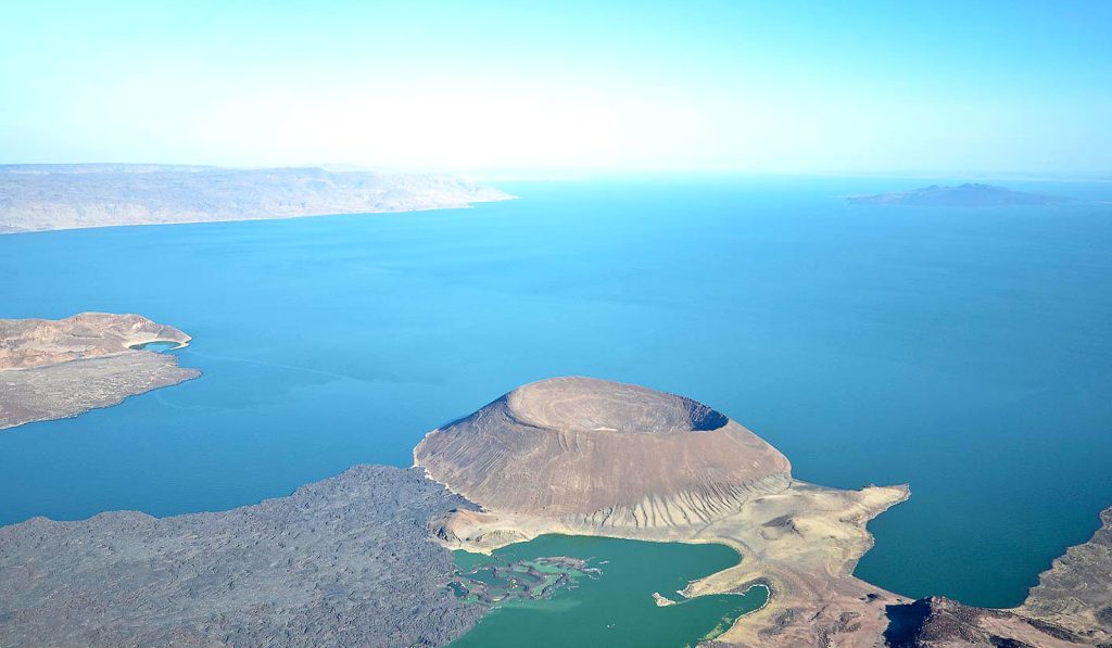
Lake Turkana—locally called the “Jade Sea” for its striking turquoise-green color—is Africa’s largest permanent desert lake and the world’s largest desert lake, period. Stretching 249 kilometers from north to south, this ancient body of water sits in one of Earth’s harshest environments: volcanic rock, extreme heat, minimal rainfall, and seemingly lifeless landscape.
But here’s where it gets incredible.
The Three Parks:
Sibiloi National Park: On the lake’s eastern shore, this park is home to the Koobi Fora archaeological site—one of the most important paleontological discovery sites on Earth.
Central Island National Park: An active volcanic island with three crater lakes—a spectacular geological formation rising from the jade waters.
South Island National Park: A barren volcanic island that serves as a breeding ground for Nile crocodiles (over 12,000 of them!) and various bird species.
Why It’s Called the “Cradle of Mankind”:
Starting in 1969, paleoanthropologists began making extraordinary discoveries at Koobi Fora. They unearthed fossils of Paranthropus boisei and Homo habilis—evidence that relatively intelligent hominids lived here 2 million years ago.
The Koobi Fora deposits contain more fossil evidence of human evolution than any other site in Africa. These finds have revolutionized our understanding of how humans evolved, how climate change shaped our ancestors (from moist forest grassland to hot desert), and where we come from.
Wildlife:
Despite the harsh environment, Lake Turkana supports remarkable biodiversity:
- Over 12,000 Nile crocodiles (one of the world’s largest populations)
- Hippos
- Venomous snakes
- 350+ recorded bird species (important stopover for migratory waterfowl)
Conservation Challenges:
Lake Turkana faces threats from dam construction on the Omo River (Ethiopia) that feeds it, potentially lowering water levels and increasing salinity. It was briefly on UNESCO’s “In Danger” list but has been removed following monitoring improvements.
Visiting Tips:
This is remote. Really remote. Most visitors fly from Nairobi. Expect extreme heat (regularly exceeding 40°C), basic facilities, and stunning, otherworldly landscapes. The El Molo fishing community offers cultural insights into survival in this harsh environment.
Mount Kenya National Park and Forest (Inscribed 1997)
Location: Central Kenya, straddling the equator
Size: Approximately 71,759 hectares
Why It’s Special: Africa’s second-highest peak with glaciers at the equator
At 5,199 meters (17,057 feet), Mount Kenya is an ancient extinct volcano crowned with rugged, glacier-clad peaks despite sitting almost exactly on the equator. The sight of permanent ice and snow at 0° latitude is surreal—a stark reminder of how altitude creates climate zones.
Outstanding Features:
Geological Marvel: Mount Kenya is about 3 million years old. Its distinctive peaks—Batian, Nelion, and Point Lenana—were carved by glaciers that are now rapidly retreating due to climate change.
Ecological Zones: As you ascend, you pass through distinct zones:
- Lower slopes: Agricultural land and forest
- Montane forest: Dense bamboo and hardwood forests
- Alpine zone: Giant heathers, lobelias, and groundsels (unique afro-alpine flora)
- Nival zone: Ice, snow, and rock
Afro-Alpine Flora: The evolution and ecology of Mount Kenya’s unique plant species provide outstanding examples of ecological and biological processes. Plants here have adapted to extreme daily temperature swings (freezing nights, hot days).
Water Tower: Mount Kenya is crucial to Kenya’s water supply. Rivers radiating from the mountain provide water to millions of people. It’s also a UNESCO Biosphere Reserve.
Wildlife: African elephants use traditional migration routes through the park. Other species include buffalo, leopards, various monkeys, and over 130 bird species.
Visiting:
Trekkers can reach Point Lenana (4,985m) without technical climbing. Batian and Nelion require serious mountaineering skills. The park offers various hiking routes, from day trips to multi-day treks. Best climbing season: January-February and August-September (driest months).
Kenya Lake System in the Great Rift Valley (Inscribed 2011)
Location: Rift Valley, includes Lake Bogoria, Lake Nakuru, Lake Elementaita
Size: 32,034 hectares
Why It’s Special: 4 million flamingos and exceptional geological features
This is where nature puts on a show. Three shallow, interconnected alkaline lakes sitting in the dramatic Great Rift Valley create one of Earth’s most spectacular bird-watching destinations.
The Flamingo Phenomenon:
Up to 4 million lesser flamingos migrate between these three lakes throughout the year, creating vast carpets of pink stretching across the alkaline waters. It’s the single most important foraging site for lesser flamingos globally.
Why here? The alkaline water supports massive algae growth (especially Spirulina), which is the flamingos’ primary food. The lakes literally turn pink from the sheer density of feeding birds.
The Three Lakes:
Lake Nakuru: Most famous and accessible. Home to Lake Nakuru National Park with rhinos, lions, leopards, Rothschild’s giraffes, and of course, flamingos (though numbers fluctuate).
Lake Bogoria: Known for hot springs and geysers along its shores. More remote than Nakuru but spectacular geology. Greater kudu populations here.
Lake Elementaita: Smallest and most alkaline. Important breeding site for great white pelicans. Less developed for tourism.
Geological Wonders:
The Rift Valley’s tectonic activity created this stunning landscape—volcanic outcrops, geothermal features (geysers, hot springs), steep escarpments. It’s a living geology laboratory.
Biodiversity:
- 13 globally threatened bird species
- Some of the highest bird diversity in the world (over 450 species recorded)
- Mammals: Black rhinos, Rothschild’s giraffes, lions, leopards, African wild dogs, greater kudus
Conservation Success:
Kenya’s lake system demonstrates successful conservation. Rhino populations have recovered through intensive protection. Rothschild’s giraffe conservation here has prevented extinction.
Visiting:
Lake Nakuru is most tourist-friendly (2-3 hours from Nairobi). Lake Bogoria requires more planning but offers hot springs you can visit. Best flamingo viewing: August-March (though seasonal variations occur).
Cultural Heritage Sites
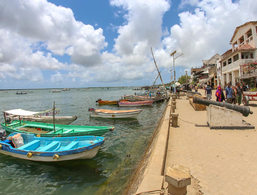
Lamu Old Town (Inscribed 2001)
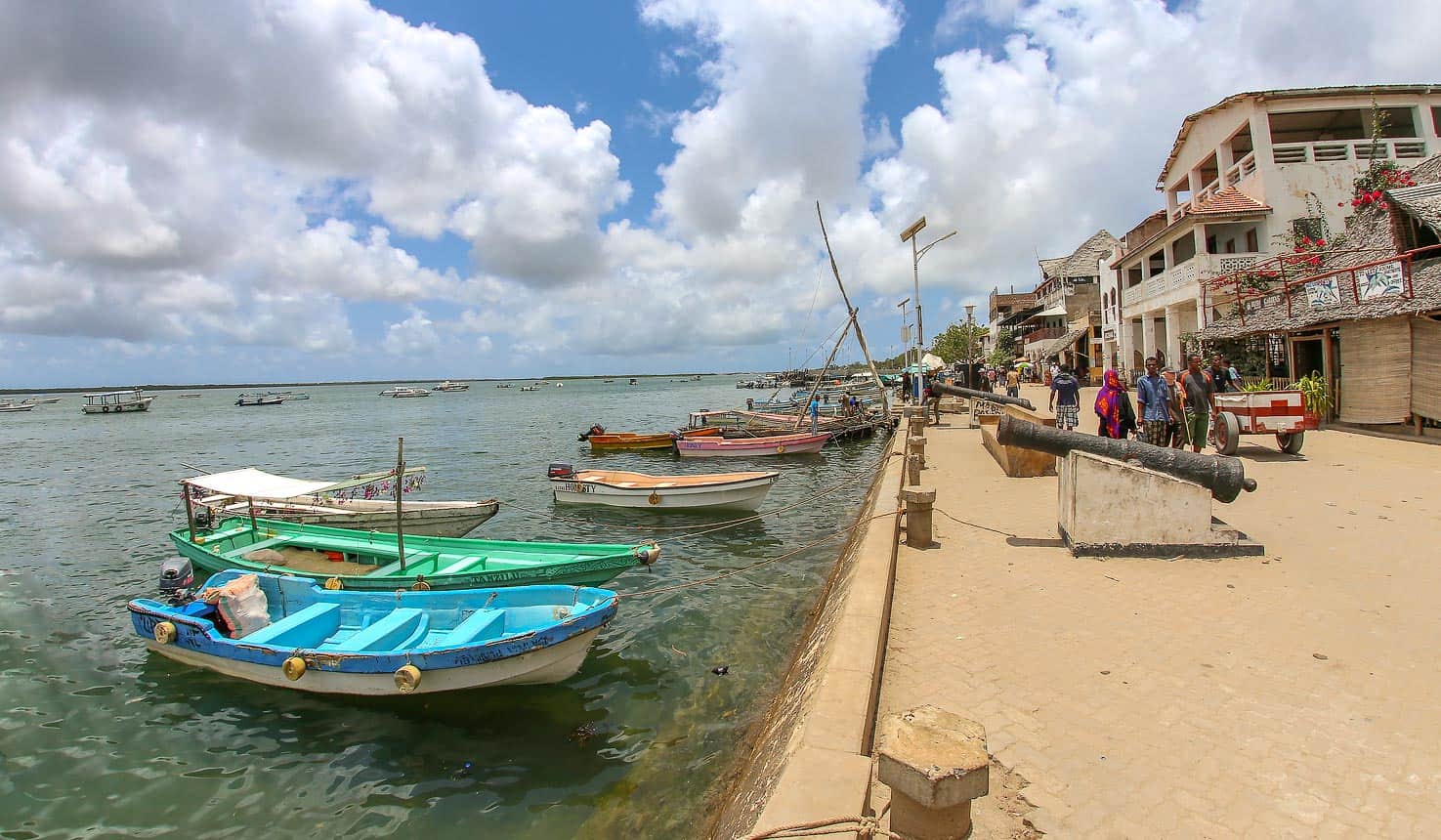
Location: Lamu Island, Lamu County (Kenya’s northern coast)
Founded: 12th century (continuously inhabited for 700+ years)
Why It’s Special: The oldest and best-preserved Swahili settlement in East Africa
Step into Lamu Old Town and you’ve stepped back in time. This isn’t a museum or reconstruction—it’s a living, breathing 700-year-old town where donkeys still outnumber cars (there are no cars), narrow coral-stone streets wind between ancient buildings, and traditional Swahili culture thrives.
Architectural Significance:
Buildings are constructed from coral stone and mangrove timber using techniques unchanged for centuries. Key features include:
- Intricately carved wooden doors (Zanzibar doors)
- Inner courtyards for privacy and cooling
- Roof terraces
- Decorative lime plaster and niches
The architecture represents a fusion of Swahili, Arabic, Persian, Indian, and European influences—physical evidence of centuries of Indian Ocean trade and cultural exchange.
Cultural Importance:
Lamu has been a center of Islamic and Swahili culture since the 19th century. It hosts major Muslim religious festivals (like Maulidi) and is considered a living repository of Swahili traditions.
Unlike other Swahili settlements along the East African coast that were abandoned, Lamu has maintained continuous habitation and traditional ways of life—making it invaluable for understanding Swahili culture.
What Makes It Unique:
- No motorized vehicles (transport by donkey, handcart, or traditional dhow boats)
- Traditional social structures and values maintained
- Swahili architecture in pristine condition
- Active traditional boat-building industry (dhows)
- Living Islamic scholarly tradition
Visiting:
Lamu is accessible by air or boat from the mainland. The town is best explored on foot—getting deliberately lost in the maze of alleyways is half the fun. Annual Lamu Cultural Festival (November) showcases donkey races, dhow races, traditional dances, and Swahili culture.
Sites to See: Lamu Museum, Lamu Fort, German Post Office Museum, numerous historic mosques, traditional Swahili houses (some offer tours).
Fort Jesus, Mombasa (Inscribed 2011)
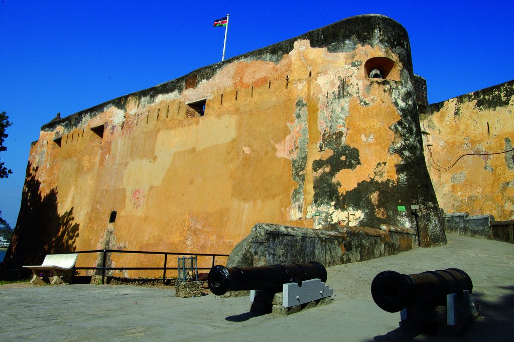
Location: Mombasa Old Town, Mombasa County
Built: 1593-1596 by Portuguese
Why It’s Special: Outstanding example of 16th-century Portuguese military architecture
Rising dramatically from coral rock overlooking Mombasa’s harbor, Fort Jesus tells the story of four centuries of conflict over control of Indian Ocean trade routes.
Historical Significance:
The fort represents the first successful attempt by Western civilization to control Indian Ocean trade, which had been dominated by Arab, Persian, and Asian powers for centuries.
Built by Portuguese architect Giovanni Battista Cairati, the fort’s design reflects Renaissance ideals: perfect proportions and geometric harmony based on the human body. From above, the fort’s layout supposedly resembles a man lying on his back.
Architectural Innovation:
Fort Jesus is one of the finest and most well-preserved examples of 16th-century Portuguese military fortification anywhere. Features include:
- Massive coral stone walls (up to 15 meters high)
- Strategic bastions for cannon placement
- Moat and drawbridge
- Interior barracks, cisterns, and storage
Cultural Layers:
The fort changed hands nine times between 1631 and 1875, controlled by Portuguese, Omani Arabs, and British. Each occupation left architectural modifications and cultural imprints, making Fort Jesus a physical chronicle of East African coastal history.
The Museum:
Fort Jesus houses an excellent museum with:
- Archaeological finds from Fort Jesus, Gede, Manda, and Ungwana
- Portuguese, Omani, and Swahili artifacts
- Historical weapons and pottery
- Chinese porcelain evidence of ancient trade networks
Visiting:
Located in Mombasa Old Town, easily accessible. Allow 2-3 hours for thorough exploration. The ramparts offer excellent harbor views. Guided tours provide historical context.
Sacred Mijikenda Kaya Forests (Inscribed 2008)
Location: Coastal Kenya (Kilifi and Kwale Counties)
Number of Sites: 11 separate sacred forests
Extent: Spread over 200 km of coastline
Why It’s Special: Living spiritual sites maintained for 500+ years
This UNESCO site is unique: 11 sacred forests containing remains of fortified villages (kayas) that are now revered as ancestral abodes by the Mijikenda people.
Historical Background:
The Mijikenda people established kayas (fortified hilltop villages) in the 16th century for protection. These villages were surrounded by forest, which provided natural defense and resources.
By the 1940s, most kayas were abandoned as people moved to coastal areas. However, the forests remained sacred—believed to house ancestral spirits and protected by councils of elders.
Spiritual Significance:
For the Mijikenda, these forests aren’t historical sites—they’re living spiritual repositories. Rituals, prayers, and ceremonies still occur here. Access is often restricted, and visitors must follow specific protocols (removing shoes, no photography in certain areas, seeking elder permission).
Ecological Importance:
These sacred forests now represent almost the only remaining coastal lowland forest in Kenya—an ecosystem otherwise destroyed by development. They harbor:
- Rare and endemic plant species
- Endangered biodiversity
- Medicinal plants used in traditional healing
Cultural Artifacts:
Within the forests lie:
- Stone ruins of kayas (walls, entrances)
- Sacred graves of ancestors
- Sacred groves and trees
- Initiation grounds
- Traditional artifacts
Conservation Model:
The Mijikenda kaya forests demonstrate how spiritual beliefs can drive conservation. Because communities revere these forests as sacred, they’ve protected them for centuries—an example of successful community-based conservation.
Visiting:
Visiting requires sensitivity and respect. Contact the National Museums of Kenya or local councils of elders for permission and guided tours. Some kayas are more accessible than others. Photography restrictions apply.
Thimlich Ohinga Archaeological Site (Inscribed 2018)

Location: Migori County, Western Kenya
Period: 15th-19th century (possibly earlier)
Why It’s Special: Largest and best-preserved stone-walled settlement in East Africa
“Thimlich Ohinga” means “frightening dense forest” in Dholuo language—a reference to the thick bush that surrounded these mysterious stone enclosures for centuries.
The Stone Structures:
Thimlich Ohinga is a massive complex of dry-stone walls (no mortar) forming enclosures:
- Walls range from 1.0 to 4.2 meters high
- Built from loose stones fitted together with incredible precision
- Complex of interconnected enclosures (like Russian dolls)
- Elongated stone slabs as lintels over gates
The engineering is remarkable—these structures have survived 500+ years without mortar, withstanding wind, rain, and vegetation.
Who Built It?
Archaeological evidence suggests Bantu peoples (who occupied the region before the Luo arrived) first built the structures 500+ years ago, possibly earlier.
Later communities (15th-19th centuries) modified and repaired the structures but preserved the original architecture. This shows continuous cultural value placed on these sites.
Why Were They Built?
Most likely for security—protecting communities and livestock from raids. The hilltop location provided defense advantages, and the stone walls created fortified compounds.
Cultural Significance:
Thimlich Ohinga represents traditional African building techniques and social organization. The complex demonstrates:
- Advanced engineering knowledge
- Community cooperation (massive labor required)
- Social hierarchy (different enclosure sizes suggest status differences)
Current State:
While some stone structures in the region disappeared, Thimlich Ohinga survived relatively intact—making it invaluable for understanding pre-colonial African settlements.
Visiting:
Located near Migori town (about 7-8 hours from Nairobi). The site offers guided tours explaining the archaeology and cultural history. Best combined with visits to nearby Rusinga Island or Ruma National Park.
Gedi Ruins (Inscribed July 2024) - NEW!
Location: Kilifi County, near Malindi
Period: 13th-17th century
Why It’s Special: Mysterious Swahili settlement with unexplained abandonment
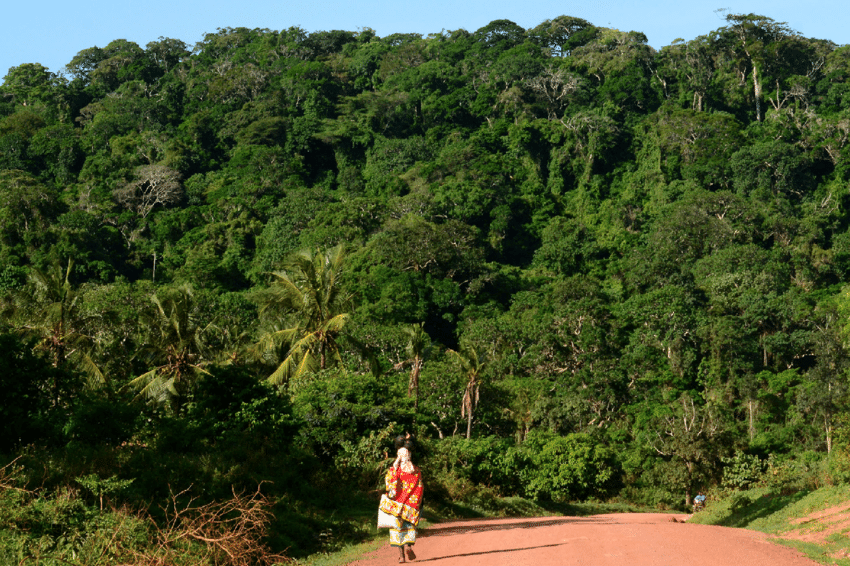
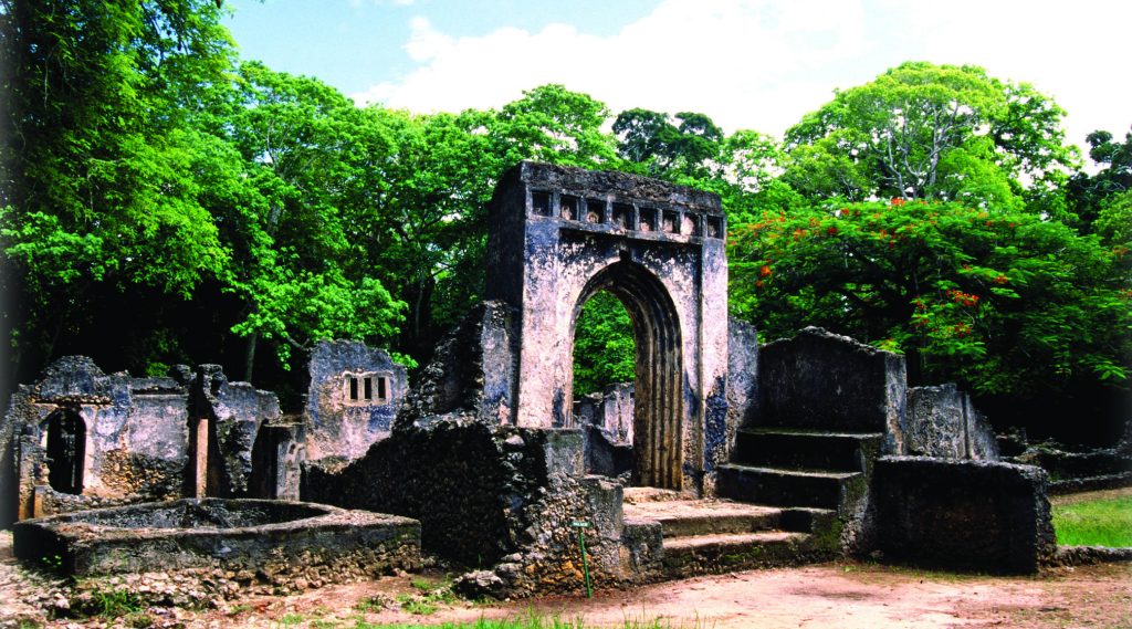
Kenya’s newest UNESCO site is also one of its most mysterious. Gedi (also spelled Gede) is a remarkably well-preserved Swahili town hidden in Arabuko-Sokoke Forest—and nobody knows exactly why it was abandoned.
The Mystery:
Unlike Lamu (on the coast), Gedi is 16 km inland. Yet excavations reveal it was a prosperous trading town with:
- Chinese porcelain
- Venetian beads
- Indian pottery
- Persian lamps
How did an inland town access international trade networks? Why was it built inland rather than on the coast like other Swahili settlements? Why was it mysteriously abandoned in the 17th century?
Archaeological Significance:
Gedi’s ruins include:
- Great Mosque and several smaller mosques
- Palace with elaborate rooms and artifacts
- Pillar tombs (distinctive Swahili burial monuments)
- Houses with stone structures, wells, and drainage
- Town walls and gates
The architecture demonstrates sophisticated Swahili building techniques and urban planning.
What Makes It UNESCO-Worthy:
Gedi provides unique insights into Swahili civilization’s inland trade routes and settlement patterns. Its excellent preservation allows detailed archaeological study. The site challenges assumptions about Swahili culture being exclusively coastal.
Visiting:
Located about 16 km from Malindi, easily accessible as a day trip. The ruins are set in beautiful Arabuko-Sokoke Forest (worth exploring for rare birds and flora). Site museum displays artifacts and explains theories about Gedi’s history.
Why These Heritage Sites Matter
Beyond their individual significance, Kenya’s UNESCO World Heritage Sites collectively tell the story of human evolution, African civilizations, cultural exchange, and natural wonders.
They generate tourism revenue that supports conservation and local communities. They preserve knowledge about architecture, ecology, spirituality, and history. They remind us that some places belong not just to Kenya, but to all humanity.
Planning Your UNESCO Sites Journey
Combining Sites:
Northern Circuit: Lake Turkana (fly from Nairobi)—very remote, requires dedicated trip
Central Highlands: Mount Kenya (accessible from Nairobi, 3-4 hours drive)
Rift Valley Lakes: Lake Nakuru/Bogoria/Elementaita (2-3 hours from Nairobi, easily combined)
Coastal Circuit: Lamu + Fort Jesus + Mijikenda Kayas + Gedi (all on coast, combine over 4-7 days)
Western: Thimlich Ohinga (combine with Lake Victoria region tours)
Best Times:
- Lake Turkana: Anytime (hot year-round)
- Mount Kenya: Dry seasons (January-February, August-September)
- Rift Valley Lakes: August-March for flamingos
- Coastal Sites: Year-round; avoid heavy rains April-May
- Thimlich Ohinga: Dry season preferred
Practical Tips:
- Some sites are remote—plan logistics carefully
- Respect cultural sensitivities (especially Mijikenda Kayas)
- Hire local guides for deeper understanding
- Entry fees support conservation
- Combine UNESCO sites with safari/beach holidays
Final Thoughts
Kenya’s UNESCO World Heritage Sites prove this country offers far more than safari wildlife. From the origins of humanity at Lake Turkana to 700-year-old Swahili towns still thriving today, from glaciers at the equator to sacred forests protected by spiritual beliefs—these eight sites showcase the extraordinary diversity of Kenya’s natural and cultural heritage.
They’re not just tourist destinations. They’re windows into human history, ecological wonders, and living cultures. They’re places of Outstanding Universal Value that belong to all of us.
And they’re waiting to be discovered.
Ready to explore Kenya’s UNESCO World Heritage Sites? Kwezi Safaris creates comprehensive itineraries combining natural wonders, cultural experiences, and wildlife encounters. From the Rift Valley’s flamingo spectacle to Lamu’s ancient streets, from Mount Kenya’s alpine glory to archaeological mysteries at Gedi, we design journeys that reveal Kenya’s full diversity. Our expert guides provide context and stories that bring these sites to life. Let’s plan your journey through Kenya’s treasures recognized by the world.